Facts & figures
SUSMETRO seeks to develop design proposals for integrated, sustainable and innovative systems linking up metropolitan (city-region) with inner- and peri-urban environments. Building upon the principles of resource efficiency, circular economy and impact assessment, the overall goal is to offer technical, procedural and strategic services for the better understanding of both economic and public stakeholders interested in system innovation at the level of urban areas and metropolitan regions.
The design proposals should build upon all relevant stages (conceptual as well as operational), different scales (from territory to building or land plot) and especially the relevant flows and places of circular economy to illustrate how urban and metropolitan agriculture can become part of the wider urban-metropolitan metabolism. The guiding principles of the sustainable design combine (1) the attention to a sense of place by applying the methods of Landscape Character Assessment (LCA) focussing on qualitative aspects, with including methodologies for assessing the link between places and flows (of resources, goods, people) between metropolitan locations, focussing on quantitative aspects of the sustainable development goals, for example by drawing up future scenarios; (2) Spatial dimensions of life-cycle analysis such as the Metropolitan Footprint Assessment for cities and regions; and tools and data management support for (3) Evidence-based Design Proposals in terms of urban planning such as ‘green figures’, architecture as well as sustainable forms of food and transport hubs.
Examples:
Landscape Character – a holistic and humane concept
“Landscape means an area, as perceived by people, whose character is the result of the action and interaction of natural and/or human factors” (European Landscape Convention, Council of Europe 2000)

Figure 1: Historical origins of landscape research in relation to other scientific and policy fields with special attention to the holistic dimension. (Wascher 2005, modified according to Antrop 2000 and Schenk 2002).
“Our society is constructed around flows of capital, of information, of technology, flows of organizational interactions, flows of images, sounds, and symbols. Flows are the expression of processes dominating our economic, political, and symbolic life.” (M. Castells, 2000)

Figure 2: Landscape-based assessment at the site-level: from spaces of place to spaces of flow (Wascher 2015)

Figure 3: Concept Plan for an Urban-Agricultural Hub at the location of Porto di Mare in the metropolitan region of Milan. Linking up to a ‘green-finger’-parkscape design, the approach is based on an geo-spatial assessment of the land use, main transport lines and urban food outlets of the region (Tadi & Wascher 2017)
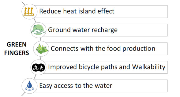
Figure 4: Functions of ‘Green Fingers’ as part of a sustainable metropolitan design concept.

Figure 5: Scenarios for a sustainable land use development in the Amsterdam Metropolitan Region. Results from a design workshop organized by the Podium for Architecture Haarlemmermeer on March 14, 2018 (Wascher 2018)
Metropolitan Footprint Assessment
Following the City-Region Food System approach (FAO and RUAF Foundation, 2015): “Improved rural-urban connectivity is critical to achieve sustainable food systems”.
The “reconnection” of agricultural production to urban food consumption is not just targeting at shorter food chains, but at more sustainable and more resilient strategies for increasing food security and food safety at the level of metropolitan regions. The underlying philosphy is inspired by the economic model developed by von Thünen in 1823 who established a set of rationales for linking the spatial distribution of land to the geographic distance of the consumer markets. Applying such food planning principles to nowadays metropolitan regions suggests that the land surrounding urban centres offer a wide range of potentials for short supply food chains with new and more varied business opportunities for local farmers and producers. Making use of Geographic Information Systems, the Metropolitan Footprint Tool (Wascher & Jeurissen 2015) allows to project the spatial configuration of agricultural lands needed to supply urban population with food. The assessment allows to specify the amount of local hectare surplus and deficits for 9 food groups (see figures 8 and 9) and can serve as an important reference for scenario development (see figure 5) at the level of workshop and living lab activities.

Figure 6: Von Thünen’s model (1823) : Translating the vision of modern metropolitan agriculture into a spatially explicit planning concept for food security requires a more dynamic approach that is based on multi-functionality, evidence-based planning principles and multi-actor governance.

Figure 7 : Result of applying the Metropolitan Footprint Planning tool (MFP) to assess the local hectares food production needs for the Amsterdam Metropolitan Region (Wascher & Jeurissen 2018). The Figure shows the Metropolitan Food Rings (MFRs) as dark-yellow rings for both Amsterdam and Almere. The large purple ring shows the production are for the whole MRA population. Forests, protected landscapes and nature conservation areas are not part of the agricultural potential.
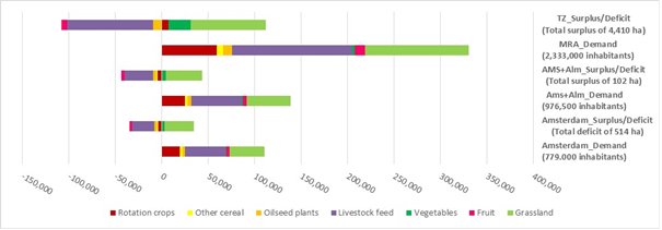
Figure 8: Surplus/ deficit and demand diagram for MRA and Amsterdam City (Wascher & Jeurissen, 2017)

Figure 9: Surplus/ deficit and demand for Almere City (Wascher & Jeurissen, 2017)
Evidence-based Food System Design: tools and data
Urban systems place enormous burdens on local and global ecosystems and are a major cause to climate change. Especially the debate around local food systems is of particular interest at the metropolitan level. The question whether local food systems are more sustainable or just than systems at other scales is still under debate (see, for example, Born & Purcell, 2006). However, the re-location of agriculture is increasingly seen as a way forward. In the Netherlands, the Planbureau voor de Leefomgeving (PBL, 2012) considers short chains as an important strategy for farmers to transition towards more sustainable production whilst ensuring affordability to consumers.
For SUSMETRO, ‘Evidence-Based Food System Design’ projects strive to address the knowledge gap described above, making use of the geo-layers approach to ensure a high level of synergy. The overall goal is to contribute to an evidence base for public as well as private stakeholders that supports them in shaping the sustainable systems. Relying on a string of methodologies and tools, SUSMETRO seeks to produce results with a clear design-oriented dimension in terms of graphical displays and illustrations, as well as data collection methods that support evidence-based design and decision-making.
To make transition work and to guide them amidst complex social, economic and environmental processes, more and better knowledge is needed on resource and waste streams as well as consumer attitudes in terms of quantity and spatial characteristics when developing new business plans and policies. This means calculation and assessment of consumer demands and possible local or regional supplies, logistics, environmental, economic and spatial consequences and interrelations.
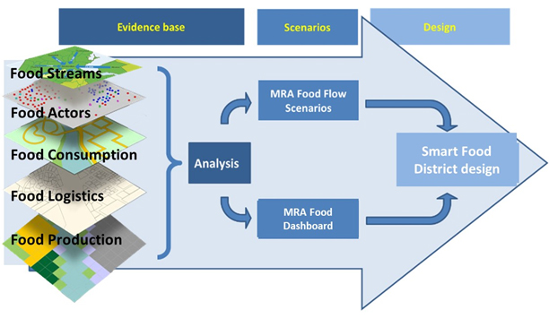
Figure 10: Evidence-based assessment process making use of the geo-data layer approach as a basis for scenario development and design proposals for Smart Food Districts.

Figure 11: Quantitative Food Flow for the Amsterdam (Jessica van Bossum, 2017).
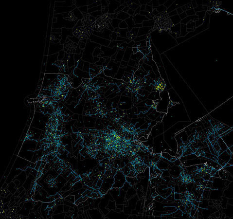
Figure 12: Retail sale – consumption in household networks (source: Bureau van Dijk Amadeus – European Company Data)

Figure 12b: Spatial analysis of metropolitan regions making use of socio-economic and bio-physical data sets for characterizing the current situation as well as future trends (Agricola 2017)
